


10+ Years of deployment experience
4 Stages: consult, integrate, deploy, support
1 Partner from mission design through support

SOLUTIONS
Explore Products

AERIAL
Drones

GROUND
Robots

DATA
Payloads & Sensors
CHOOSE BY MISSION
The work defines
The solution
DPR brings aerial platforms, ground robots, sensors and software together into practical systems designed around the outcome not the equipment catalog.

LWIR Optical Gas Imaging Payload
LWIR optical gas imaging camera designed for continuous detection of larger hydrocarbon leaks.

MWIR Optical Gas Imaging Payload
MWIR optical gas imaging camera designed to detect and visualize methane and other hydrocarbons.

Humanoid Robots
Lightweight humanoid robot designed for development, research and intelligent mobility.

Humanoid Robots
Advanced full size humanoid robot designed for AI, research and industrial applications.

Quadruped Robots
Advanced quadruped robot platform designed for education, research and autonomous development.

Quadruped Robots
Agile quadruped robot designed for research, development and intelligent mobility.

Humanoid Robots
Unitree G1-D dual-arm humanoid platform for manipulation research, data collection and embodied AI development, with Standard and mobile Ultimate configurations.

Humanoid Robots
Compact humanoid robot designed for AI research, manipulation and embodied intelligence.
WHAT WE SOLVE
Start with the mission
Then choose the technology
DPR brings aerial platforms, ground robots, sensors and software together into practical systems designed around the outcome not the equipment catalog.
ONE OPERATING PICTURE
Intelligence from
sky to ground
Drones see the big picture. Robots go where aerial systems cannot. Together, they create safer, more complete and repeatable workflows.
Intelligence from sky to ground
Drones see the big picture. Robots go where aerial systems cannot. Together, they create safer, more complete and repeatable workflows.
ONE OPERATING PICTURE
SOLUTIONS
Explore Industries

Oil & Gas
Industrial inspection, methane detection, site monitoring, and asset intelligence for demanding oil and gas environments.

Utilities
Smarter inspection, mapping, and maintenance support for power, water, and other essential utility networks.

Construction
Surveying, progress tracking, site documentation, and inspection tools built for modern construction projects.

Mining
Advanced mapping, monitoring, and inspection capabilities for safer and more efficient mining operations.

Ranching/Agriculture
Advanced drone and sensing solutions for ranching and agriculture, including livestock monitoring, crop analysis, pasture assessment, field mapping, and precision spraying.

Public Safety
Mission focused systems for emergency response, search and rescue, security, and situational awareness.

Research & Education
Flexible platforms for experimentation, technical training, academic research, and advanced robotics development.

Environmental
Technology for emissions tracking, environmental assessment, habitat monitoring, and large area data collection.
WHY DPR
Not a box seller
Your deployment partner
“The technology is only useful when it works in your environment, with your people, and produces data you can act on.”
02
Integrate
Bring platforms, sensors and software together.
03
Deploy
Move from demonstration to an operational system.
03
Support
Keep the program productive in the field.
TRUSTED IN THE FIELD
“Drones Plus personnel are knowledgeable, professional and always helpful. I especially value being able to see the equipment firsthand and get expert advice before making major investments.”
— Customer, $6B international building materials company


Better questions better system decisions
Connect the mission to the right sensing method, platform and deployment approach.
INSPECTION ● MAPPING ● METHANE ● AUTONOMY ● PUBLIC SAFETY

Drones Plus Robotics deliver innovative commercial and specialized applications, offering businesses advanced solutions for efficiency, safety, and growth.

Cutting edge drones and robotic systems enable precise environmental and agricultural monitoring, improving sustainability, crop health, and resource management.

Robotics and drone technology revolutionize industrial and infrastructure inspection, ensuring accurate data collection, reduced downtime, and enhanced safety.

Drones and robotics strengthen public safety and security by providing real-time surveillance, rapid response, and advanced threat detection.


The DJI Matrice 400 paired with the Zenmuse L3 LiDAR delivers a complete aerial mapping and inspection solution designed for industrial precision. With its 59 minute flight endurance and 6 kg payload capacity, the Matrice 400 provides stability and power for complex missions.
The L3 LiDAR captures dense, high accuracy 3D data at ranges up to 950 meters, complemented by dual 100 megapixel RGB cameras for vivid, georeferenced imagery. Together, they streamline data collection from flight to final model making surveying, terrain modeling, and infrastructure analysis faster, safer, and more reliable.


Precision redefined long range, dual camera LiDAR built for professional mapping and inspection.
Transform Your Business with Customized Drone and Robotics Solutions
At Drones Plus Robotics, innovation meets expertise to deliver tailored strategies that drive corporate excellence.
We provide advanced drone and robotics solutions for construction, public safety, energy, and agriculture, helping organizations improve efficiency, enhance safety, and achieve measurable success.
Let our team of professionals guide you in breaking barriers and transforming your business landscape.
Pinnacle
of
Innovation
for
Enterprise




WHAT CLIENTS SAY
“The experts at Drones Plus Dallas have supported the Frisco Police Department’s drone program since its start in 2019.
Their fast and friendly service has been key to our success in UAS operations and in testing new ways to better serve our community’s needs. This partnership reflects our commitment to innovation, safety, and protecting both citizens and officers.
Thank you, Drones Plus Dallas, for your continued support of the Frisco Police Department Drone Team.”
- Frisco PD
WHAT CLIENTS SAY
"The guys were great! They reset my drone , calibrated and got it ready for take off! Appreciate you guys for the tour, tips and and tricks!"
- Juan A
WHAT CLIENTS SAY
"Took my son’s crashed DJI Mini in for repair and they had me taken care of quickly. A+ service!"
- Wesley D
WHAT CLIENTS SAY
"It is a company with very good professionals who give you confidence and very good attention and quick solutions."
- Erik R
WHAT CLIENTS SAY
"I want to personally thank you and the entire staff for the incredible service and support.
As a customer for three years, Drones Plus has been instrumental in helping me build a solid foundation for my drone business. You have consistently gone above and beyond with technical assistance, hands-on flying help, parts servicing, and product knowledge.
No doubt Drones Plus is the best! I began as a customer, and now I am proud to continue as a friend."
- Brian
WHAT CLIENTS SAY
Drones Plus personnel are knowledgeable, professional, and always helpful.
I rely on drones to measure inventory, and they have guided me with equipment selection, maintenance, and surveying questions. They also stay current with FAA rule changes and proposals.
They have been terrific to work with over the years. I especially value being able to visit their shop, see the equipment firsthand, and get expert advice before making major investments.
— Eric W, $6B international natural resource-based building materials company
WHAT CLIENTS SAY
I want to express my appreciation for the support Drones Plus Dallas has provided me.
As someone implementing a drone program for a large general contractor, I rely on your team for advice, equipment, technical support, repairs, and even warranty advocacy. You have been instrumental in getting our program off the ground.
Most of all, I value the friendliness and dedication of your staff. Garrett, Paul, Ervin, Darrius, Steven, and Robert always go above and beyond—and even put up with my jokes.
Thank you and your team for everything you do.
- Edward K

Our robotics and drone solutions combine cutting-edge ground robots with advanced aerial platforms for industrial, research, and service applications. Unitree robots such as the B2W, B2, Go2, R1, G1, and A2 deliver powerful mobility, stability, and intelligent interaction across challenging environments and educational settings. DJI enterprise drones, including the Matrice 400, Mavic 3 Enterprise, L2 LiDAR Scanner, and Drone Dock 3, provide reliable mapping, inspection, and fully automated operations. Together, these robotics and drone systems offer complete solutions for automation, safety, and efficiency.

Our robotics and drone solutions combine cutting-edge ground robots with advanced aerial platforms for industrial, research, and service applications. Unitree robots such as the B2W, B2, Go2, R1, G1, and A2 deliver powerful mobility, stability, and intelligent interaction across challenging environments and educational settings. DJI enterprise drones, including the Matrice 400, Mavic 3 Enterprise, L2 LiDAR Scanner, and Drone Dock 3, provide reliable mapping, inspection, and fully automated operations. Together, these robotics and drone systems offer complete solutions for automation, safety, and efficiency.
Our robotics lineup features advanced quadruped and humanoid robots built for real-world applications. Unitree robots like the B2 and A2 provide unmatched strength and stability for industrial tasks, while the R1 and G1 humanoids bring intelligent interaction and dexterity to service and research environments. The Go2 offers a versatile platform for education and exploration, making robotics more accessible for learning, innovation, and daily use.

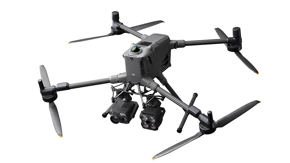
Our drone solutions deliver precision, efficiency, and reliability for professional applications. Autel and DJI enterprise drones such as the Matrice 400, Mavic 3 Enterprise and Autel EVO II Enterprise V3 offer long flight times, powerful imaging, and multi-payload flexibility for surveying and inspection. With the L2 LiDAR Scanner providing high-accuracy 3D mapping and the Drone Dock 3 enabling fully automated operations, these aerial platforms help businesses streamline workflows, enhance safety, and unlock the full potential of autonomous drone technology.
Our software solutions power the full potential of robotics and drones by enabling real-time control, advanced AI processing, and seamless data management. From mission planning and autonomous navigation to cloud-based analytics and reporting, the software ensures smooth integration between ground robots, aerial platforms, and enterprise systems. With user-friendly interfaces and scalable features, it helps organizations maximize efficiency, improve safety, and gain actionable insights from every operation.


We provide expert DJI drone repair for both enterprise and consumer models. Our certified technicians specialize in the Matrice series, Mavic series, Inspire series, Avata, and Phantom drones, as well as the Mini series.
From broken cameras and damaged parts to software glitches and flight performance issues, we use genuine DJI parts and trusted repair methods to restore your drone to peak performance. Fast diagnostics and reliable service get you back in the air quickly.